


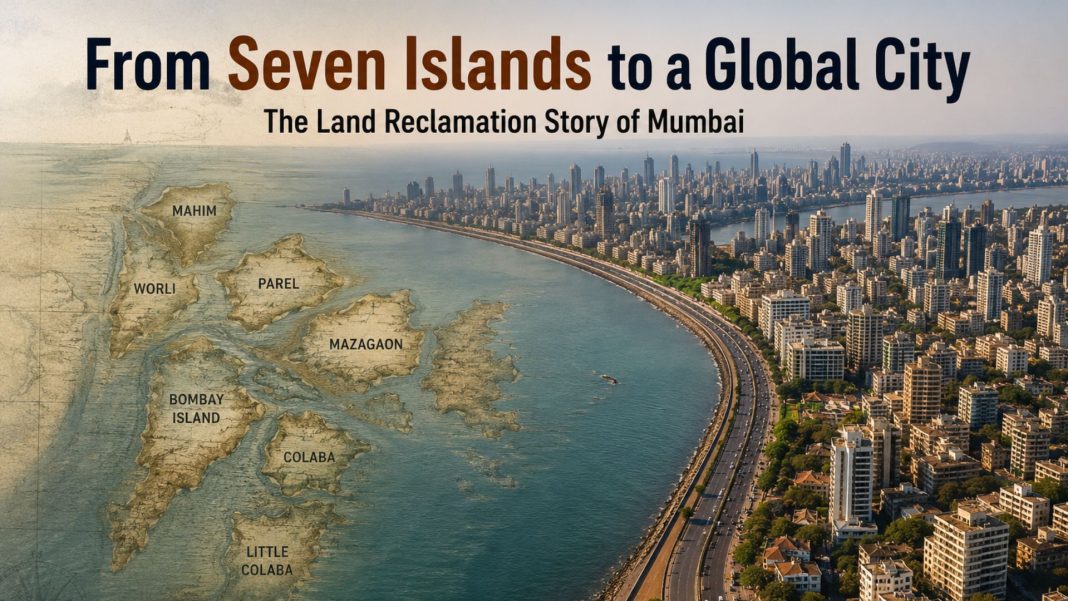

Mumbai Land Reclamation: Today, Mumbai is known as India’s financial capital, the home of Bollywood, and one of the world’s busiest metropolitan cities.
Millions of people travel through its streets every day, while landmarks such as Marine Drive, Nariman Point, and the city’s bustling business districts define its modern identity.
Yet, according to historical records and media reports, Mumbai did not begin as a single continuous landmass. Instead, it was once a collection of seven separate islands divided by creeks, marshes, and tidal waters.
The city’s transformation into the Mumbai we know today was made possible through a series of land reclamation projects carried out over several decades.
Rather than creating an entirely new city from the sea, these engineering efforts gradually connected the islands and reclaimed selected coastal areas, laying the foundation for one of India’s most important urban centres.
Mumbai Was Originally a Group of Seven Islands
Mumbai Land Reclamation: According to historical accounts, the region that now forms South Mumbai consisted of seven islands: Bombay Island, Colaba, Little Colaba (Old Woman’s Island), Mazagaon, Parel, Worli, and Mahim.
These islands were inhabited long before British rule, with the indigenous Koli fishing community among the earliest known settlers.
The islands were separated by tidal creeks and low-lying marshlands. During high tide, many routes disappeared underwater, making movement between settlements difficult.
Boats served as the primary mode of transport, while travel during the monsoon season became even more challenging due to flooding and rough sea conditions.
Why the British Decided to Connect the Islands
Mumbai Land Reclamation: After the islands came under British control through the East India Company, Bombay’s natural harbour quickly emerged as a valuable trading location.
According to historical records, British administrators recognised that connecting the scattered islands would improve transportation, expand usable land, and strengthen the city’s role as a commercial port.
This vision eventually led to a series of ambitious land reclamation projects. Instead of allowing the sea to separate the islands, engineers began filling shallow creeks and marshy areas with stone, soil, and other materials to create continuous land connections.
The Hornby Vellard Project Played a Key Role
One of the earliest and most significant engineering efforts was the Hornby Vellard project, initiated during the tenure of Governor William Hornby in the late eighteenth century.
According to historical references, the project focused on closing the Great Breach near Worli, which regularly allowed seawater to flood surrounding low-lying areas.
The sea wall and connected reclamation work helped reduce flooding while opening new land for settlement and infrastructure.
Although Hornby Vellard became one of the defining milestones in Mumbai’s development, it was only one phase in a much longer process that continued through the nineteenth century with several additional reclamation projects.
Land Reclamation Continued for Decades
The transformation of Mumbai did not happen overnight. According to media reports and historical documents, different reclamation projects continued across the nineteenth and twentieth centuries.
Later developments included the reclamation of parts of Back Bay, which eventually contributed to the creation and expansion of areas that today include Marine Drive, Nariman Point, and Cuffe Parade.
Some planned reclamation projects were modified or even abandoned over time due to financial challenges, public criticism, and policy decisions, showing that Mumbai’s development evolved in multiple stages rather than through a single construction project.
A Common Myth About Mumbai
One popular claim often shared on social media is that “Mumbai was completely built on the sea.” Historical evidence, however, presents a more balanced picture.
The seven original islands were naturally existing landforms long before British rule. What changed over time was the landscape between them.
According to historical records, large portions of marshes, creeks, and shallow coastal waters were reclaimed to physically connect these islands and create additional urban land.
Therefore, it is more accurate to say that modern Mumbai was expanded through land reclamation, rather than stating that the entire city was created from the sea.
The Legacy of Mumbai’s Transformation
The reclamation projects fundamentally reshaped Mumbai’s future. By creating larger connected land areas, they enabled the construction of roads, railways, ports, commercial districts, and residential neighbourhoods that supported the city’s rapid economic growth.
Today, Mumbai remains India’s financial powerhouse, hosting major financial institutions, the Bombay Stock Exchange, Bollywood, and one of the country’s busiest ports.
While the skyline has changed dramatically over the centuries, the city’s geography still reflects the remarkable engineering efforts that united seven islands into one of the world’s most recognised urban landscapes.
Conclusion
Mumbai’s history is not simply the story of a city rising from the sea. It is the story of how seven naturally existing islands were gradually connected through carefully planned land reclamation projects that unfolded over generations.
According to historical records and media reports, these engineering achievements transformed scattered islands into a thriving metropolis without erasing their original geography.
Understanding this history offers a deeper appreciation of Mumbai’s remarkable journey from a cluster of coastal islands to India’s financial capital and one of the world’s most iconic cities.